by Priyanwada Atapattu
How AI, GIS, and Real-Time Spatial Mapping Are Transforming Urban Sustainability
Introduction
Cities around the world are increasingly facing environmental challenges driven by climate change, rapid urbanization, biodiversity loss, urban heat islands, and aging infrastructure. Rising temperatures, extreme rainfall events, flooding, and declining environmental quality are forcing governments, urban planners, and researchers to search for smarter and more adaptive solutions for sustainable urban development. Among the many emerging technologies shaping the future of urban planning, digital twins are rapidly becoming one of the most transformative tools for building climate-resilient cities.
What Is a Digital Twin?
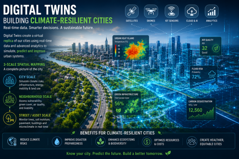
A digital twin is a virtual representation of a real-world system that continuously updates using real-time data. In urban planning and urban ecology, digital twins integrate technologies such as Geographic Information Systems (GIS), remote sensing, Artificial Intelligence (AI), Internet of Things (IoT) sensors, cloud computing, big data analytics, and 3D spatial mapping. Together, these technologies create dynamic digital models capable of simulating environmental conditions, infrastructure performance, and future climate scenarios. Unlike traditional static maps, digital twins provide continuous environmental monitoring and predictive capabilities that support faster and more informed decision-making.
Why Digital Twins Matter for Climate-Resilient Cities
The growing importance of digital twins lies in their ability to help cities prepare for climate-related risks before disasters occur. Climate-resilient cities require planning approaches that are flexible, data-driven, and capable of responding to rapidly changing environmental conditions. Digital twins allow planners and policymakers to visualize urban climate risks in real time and test potential solutions virtually before implementing them physically. This technology is increasingly being used for urban climate adaptation, flood risk assessment, urban heat island mitigation, smart transportation systems, sustainable infrastructure management, biodiversity conservation, urban forestry monitoring, and disaster preparedness planning.
The Role of Multi-Scale Spatial Mapping
One of the most innovative features of digital twin technology is its ability to integrate environmental information across multiple spatial scales. At the city scale, digital twins can analyze heat distribution, flood-prone zones, transportation systems, air pollution patterns, land-use change, and energy consumption. This large-scale analysis helps governments identify climate vulnerabilities and prioritize adaptation investments more effectively.
At the neighborhood scale, digital twins can assess tree canopy cover, green infrastructure, walkability, stormwater runoff, environmental inequality, and local climate exposure. Such analyses support more equitable and environmentally informed urban planning decisions.
At finer spatial scales, digital twins can monitor individual urban assets and environmental conditions in real time. These systems can track individual street trees, vegetation health, soil moisture, pavement conditions, building energy performance, and microclimatic variation. This detailed monitoring capability is particularly valuable for urban ecology and urban forestry research because it enables continuous observation of ecological processes within highly dynamic urban environments.
Digital Twins and Urban Ecology
The integration of digital twins into urban ecology is opening new opportunities for environmental research and sustainable city management. Urban ecosystems are influenced by complex interactions between human activities, infrastructure, vegetation, climate, and land use. Digital twins provide a framework for understanding these interactions through real-time environmental analysis and predictive modeling.
For example, digital twins can help identify areas vulnerable to urban heat stress, optimize locations for urban tree planting, monitor vegetation health remotely, simulate stormwater movement, and predict climate-related ecosystem impacts. This creates a stronger connection between ecological science and practical urban planning.
Smart Cities and the Future of Urban Sustainability
The global smart city movement is accelerating the adoption of digital twin technologies. Cities such as Singapore, Helsinki, and Shanghai are already using digital twin platforms to improve transportation systems, reduce carbon emissions, manage flood risks, and optimize urban infrastructure.
As artificial intelligence, remote sensing, and geospatial technologies continue to advance, digital twins are expected to become even more sophisticated. Future systems may integrate autonomous environmental monitoring, real-time climate simulations, AI-driven sustainability planning, predictive ecological modeling, and advanced biodiversity assessments. The future of urban sustainability will increasingly depend on how effectively cities can integrate ecological intelligence with digital infrastructure.
Challenges and Limitations
Despite their growing potential, digital twins also face several challenges. High implementation costs, complex data integration, technical expertise requirements, and data privacy concerns remain important limitations, particularly for developing cities with limited technological infrastructure. Access to high-resolution environmental data can also be difficult in many regions.
However, rapid improvements in cloud computing, open-access spatial data, and environmental sensing technologies are gradually making digital twin systems more accessible and affordable.
Conclusion
Digital twins are no longer futuristic concepts limited to experimental smart cities. They are becoming practical tools for helping cities adapt to climate change, improve sustainability, and strengthen urban resilience. By integrating real-time environmental monitoring with predictive analytics and multi-scale spatial mapping, digital twins provide a powerful framework for understanding and managing complex urban ecosystems.
As cities continue to face environmental uncertainty, digital twins may become one of the most important technologies shaping the future of climate-resilient urban planning and sustainable urban development.
Add comment
Comments